
Geographical location of Goa
- Goa was under Portuguese colonial rule till 19th December 1961 when Indian Military Forces liberated it with the help of Freedom Fighters.
- Thereafter, the territory was incorporated into the Indian Union.
- On 30th May 1987 Goa was granted full-fledged Statehood and with this the process of decentralization of administration started.
- Goa was included as twenty-fifth state of India.
- Goa state has two districts namely North Goa headquarter at Panaji and South Goa headquarter at Margao.
The Coolest Place in India
- ‘Now our road takes us to the magnificent kingdom of Goa.
- The people of this kingdom are strong, prudent and very hardworking.
- The kingdom of Goa is the most important in India.
- It is civilized, having famous orchards and water.
- It is the coolest place in India and it is the most plentiful in foodstuffs.’
- ‘The white people make a practice of going to the kingdom of Goa to enjoy the shade and the groves of trees and to savour the sweet betel.’
- These revealing remarks on Goa come not from the hippies or ‘flower power’ generation of the sixties and early seventies who thronged the beaches of Anjuna, Vagator and Arambol in search of salvation and ‘peace’.
- These remarks were made over five centuries ago by the Portuguese Ambassador to China who visited Goa around the year 1511.
- They serve as a vivid precursor to the generations that followed in our times to the fabled land of Goa.
Location and Area of Geographical location of Goa
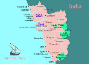
- Goa, situated along Konkan coast of India, has a coastline of 131 kms.
- The State is bestowed by nature with lovely coastal tracks along the Arabian sea and beautiful hill ranges of Western Ghats.
- It has a partly hilly terrain with the Western Ghats rising to nearly 1200 mtrs. in some parts of the state.

- In the North, the Terekhol river separate Goa and Maharashtra. Karnataka lies to the south.
- The Arabian Sea is situated on the west and the Western Ghats in the east.
- The Tiswadi Island lies between the Mandovi and Zuari rivers, which are connected on the landward side by a creek.
- The island is triangular in shape that divides the harbour of Goa into two parts Aguada at the mouth of Mandovi on the north and Mormugao at mouth of Zuari on the south.
- Goa stretches out to a length of 105 km from north to south and is about 60 km. in width from east to west.
- The State has geographical area of 3702 Sq. Kms.
- It is comparatively a small state with its capital at Panjim
Administration
- The Goa State administratively is divided into two Districts: North Goa District comprising 6 talukas with a total area of 1736 sq. kms and South Goa comprises 5 talukas with an area of 1966 sq. kms.
- The North Goa district is subdivided into 6 blocks Pernem, Bardez, Bicholim, Sattari, Tiswadi, Ponda and the South Goa district is subdivided into 5 blocks Cancoana, Sanguem, Quepem, Salcete and Murmugao.
- The head quarter of North Goa district is at Panjim and of South Goa district is at Margao.
- There are 383 revenue villages in the state of which 233 are in North Goa and 150 in South Goa.
- Besides there are 44 towns including 14 municipal towns, The State administration is looked after by the Council of Minister under the guidance of the Chief Minister.
- The Governor is the Head of the State and the Chief Secretary, the head of the administrative set up.
- The Collector of North Goa and South Goa Districts are respectively in-charge of the district level Administration.
- At the Taluka level there are Mamltdar and at the block level Block Development Officers.
- 233 revenue Village of North Goa District are grouped into 122 Village Panchayat and 70 revenue villages of South Goa District are grouped into 65 village Panchayat, thus making a total of 192 village Panchayats which take care of village Panchayat Administration.
- At the Village level, Panchayat level Administration is looked after by the Sarpanch, assisted by no of Panchas, in the implementation of various Programme as well as in serving local needs.
Detailed explanation of Geographical location of Goa
- The State of Goa is located along the West Coast of India with a geographical area of 3702 Sq. kms.
- It is situated between the latitudes N14°53’ 57” and N15° 47’ 59” and between longitudes E73° 40’ 54” and E74° 20’ 11”.
- The north to south length of the State is about 100 km while the east to west width is about 55 km.
- It is bounded in the north by the Sindhudurg district of Maharashtra, in the north-east by Belgaum district of Karnataka, in the east and south by Uttar Kannada district of Karnataka and in the west by the Arabian Sea.
- Major part of Goa form a part of the Konkan- Kanara coastal lowland region which is bounded in the east by the Western Ghats escarpment (Sahyadri mountain range).
- The State is well connected to the rest of the country by road with NH17 and NH4A highways, by rail with Konkan Railway and South Western Railway and by air through Dabolim Airport.
- The Mormugao port located on the coast of Goa is a premier hub for maritime trade of India and ranks among the top ten iron ore exporting ports of the world.
- Renowned for its beautiful beaches, places of worship and world heritage architecture, Goa is visited by large numbers of international and domestic tourists every year.
- The State is divided into two districts, namely North Goa and South Goa district with their headquarters at Panaji and Margao respectively.
- The North Goa district comprises of six talukas, namely Pernem, Bardez, Tiswadi, Bicholim, Ponda and Sattari while the South Goa district comprises of five talukas, namely Mormugao, Salcete, Quepem Sanguem and Canacona. Panaji is the capital city of the State.
- As per Census 2011 (Provisional), the population of the State is 14.57 lakhs with a population density of 394/Sq. Kms.
- The coastal talukas are more populous compared to the inland talukas.
- There are 14 statutory towns, 56 census towns and 334 villages in the State.
- Goa has emerged as one of the developed States of India with high per capita income, high literacy rate, better health care facilities and better standard of living.
- Goa is endowed with rich natural resources such as forests, navigable rivers, valuable mineral ore deposits like iron and manganese, fertile agricultural land, abundant rainfall, considerable marine and inland fishing potential, beautiful coastline and an important natural harbour.
Physical Division of Geographical location of Goa
Goa as a region can be divided into four physical divisions-
- The eastern hill region comprising areas in the western ghat like Sattari, Ponda, Cancona and Sanguem
- The Central valley land comprising Pernem, Bicholim, Ponda, Eastern Sanguemand Quepem
- The flood plains comprising the coastal plains and uplands
- Coastal plains with the areas of Tiswadi, Murmugao, Bardez and Salcete.
Final Destination for Goa PSC Notes and Tests, Exclusive coverage of GPSC Prelims and Mains Syllabus, Dedicated Staff and guidence GOAPSC Notes brings Prelims and Mains programs for GOAPSC Prelims and GOAPSC Mains Exam preparation. Various Programs initiated by GOAPSC Notes are as follows:-
- GOAPSC Mains Tests and Notes Program
- GOAPSC Prelims Exam 2024- Test Series and Notes Program
- GOAPSC Prelims and Mains Tests Series and Notes Program
- GOAPSC Detailed Complete Prelims Notes